

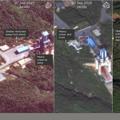
A planned satellite constellation will be able to image any location on Earth every 15 minutes and take more detailed images, a novel capability that could reveal even the nimblest and stealthiest military maneuvers, its developer says.
On Thursday, Vantor announced plans to enlarge its current fleet of 10 satellites “five-fold” with spacecraft that will produce images with 20cm resolution—better than its current 30- and 40cm imagery. The company also plans to add 40 satellites with lower-resolution cameras. When the constellation is complete some time after 2029, Vantor officials said it will vault the company to the forefront of the space-imagery industry.
“The geo accuracy of our exquisite data combined with the revisit data—we can actually fuse that data and have highly accurate imagery that nobody else can do,” Vantor CEO Dan Smoot said in an interview.
The space-imaging race
The planned constellation is part of the increasing competition between space-imaging giants.
Maxar, which renamed itself Vantor in 2025, was created by the merger of Maxar Intelligence, with its two synthetic aperture radar satellites, and DigitalGlobe, whose Quickbird had a high-for-its-day resolution of 2.4 meters. The new company focused on satellites of higher and higher resolution.
Its services were generally complementary to those of Planet, whose cheaper, smaller, lower-orbit satellites collected lower-resolution imagery more often and over a much larger portion of the Earth. But in 2023, Planet became the first company to offer high-resolution imagery and persistent coverage when it launched the first of its six 30cm Pelican satellites.
Today, Vantor’s Smoot says the U.S. government and other customers are increasingly seeking imagery for damage assessment.
“We’ve seen a lot in Ukraine, of course, and we’re starting to see that utilization in the current conflict” in the Middle East, he said.
Vantor’s planned Pulse constellation will enable it to take twice as many photos of a given area than its competitors, while its Vantage satellites will take pictures with 10cm finer resolution than Planet’s Pelican can produce. That sort of capability can reveal operations that are extremely difficult to spot, such as a submarine surfacing, as Vantor demonstrated in a picture it provided to Defense One.
But advantages in resolution and revisit are fleeting. Planet has its own plans to add higher- and lower-resolution satellites, the company said this week. And other competitors are emerging such as Austin-based SkyFi, which NATO selected for an accelerator program in December. More importantly, satellite images, once an exclusive capability of the U.S. military, are empowering adversaries. Russia is reportedly providing Iran with satellite imagery to help target U.S. forces. Other militaries want imagery to help guide strikes in GPS-denied areas or by artillery and rockets that lack internal guidance systems.
“As you can imagine, you need to be accurate within a couple meters,” said Smoot. NATO allies and other countries are “starting to really learn the value of that as they start to rearm, and they also start to realize that they don’t have those inherent capabilities built into their national defense systems.”
But the rise of AI may be the biggest reason that Vantor and others are building hybrid constellations of high- and low-resolution satellites. A single system for high-res and low-res imagery and AI analysis allows customers to better manage the security of their data. The company’s Tensorglobe platform enables customers to obtain data without switching providers.
All of that is enabling a new era of satellite imaging that would give smaller countries the ability to target missiles as effectively as larger ones.
“That is actually one of the most unique propositions about us doing this hybrid constellation,” Smoot said. “The way we’re doing it, it actually will bring that what we call targeting-grade categorization to sovereign nations.”
In other words, as the competition intensifies, hiding from the sky will become more difficult for everyone.
